Trail Walking La Grave - L'aiguille du Goléon - Photo
 tracegps
tracegps

User

© OpenStreetMap contributors
Length
Length
9.1 km
Max alt
Max alt
3406 m
Uphill gradient
Uphill gradient
1544 m
Km-Effort
Km-Effort  
25 km
Min alt
Min alt
1917 m
Downhill gradient
Downhill gradient
67 m
Boucle
Boucle
No
Creation date :
2014-12-10 00:00:00.0
Updated on :
2014-12-10 00:00:00.0

(1 Reviews)

Walking
Walking
5h00
Difficulty : Very difficult

Scan this QR Code to open this trail in the SityTrail application

FREE GPS app for hiking

Logo SityTrail SityTrail

IGN / Geographical institutes

Download SityTrail from the App Store Download SityTrail from Google Play

Logo SityTrail SityTrail World

The world is yours!

Download SityTrail from the App Store Download SityTrail from Google Play Download SityTrail on Huawei AppGallery

About

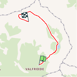
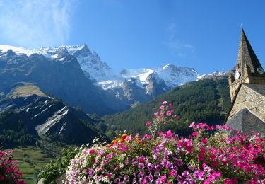
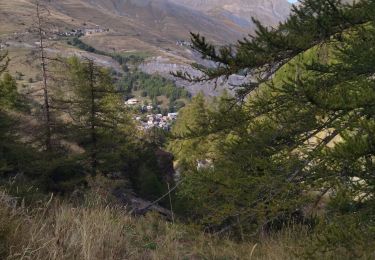
Trail Walking of 9.1 km to be discovered at Provence-Alpes-Côte d'Azur, Hautes-Alpes, La Grave. This trail is proposed by tracegps.

Description

Une très jolie course d’initiation, facile, avec option bivouac conseillée. C’est peut-être l’occasion de changer les habitudes. Il y a une vie après les nuitées en refuges ;-) La notion d’aventure n’est qu’un produit de l’esprit humain. C’est dans chacune de nos têtes que n’importe quel projet peut obtenir ce statut. Surprises, engagement, découvertes, adaptation, il ne faut pas d’immenses challenges insurmontables pour déjà avoir en bouche le goût inégalable de l’itinéraire « aventure ». Les sensations sont là, devant vos yeux. A portée de crampons. Un bivouac, au pied du glacier, par nuit claire. Des odeurs, des bruits inédits… Laissez votre imaginaire galoper, bienvenu dans l’Aventure, Mike Horn n’a qu’à bien se tenir… Consulter impérativement les conseils et descriptions sur Montagne Cool

Elevation profile

Photos

Positioning

Country:
France
Region :
Provence-Alpes-Côte d'Azur
Department/Province :
Hautes-Alpes
Municipality :
La Grave
Location:
Unknown
Start:(UTM)
290412 ; 4993978 (32T) N.

Comments

Please log in to post a review or rate the element


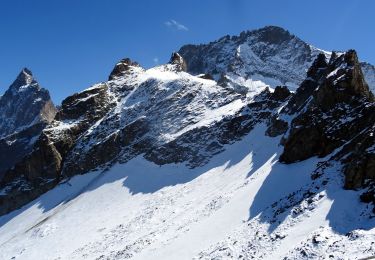
Ayant été jusqu'au pied du glacier en passant par un très long névé, je n'ai pas l'impression que ce soit si simple que ça. Impossible de passer sans être bien équipé car l'accès à l'arète me paraît bien raide et l'arète bien vertigineuse nécessitant du matériel d'escalade. Le glacier a pas mal régressé par rapport à la photo


Trails nearby

Trail Walking La Grave - vallons de la Meije : lac Puy Vachère - Photo
Walking
GUIDE
nadinebondoux

Walking

Very difficult
La Grave, Provence-Alpes-Côte d'Azur, Hautes-Alpes, France
12.7 km | 27 km-effort
5h 44min
Yes
Trail Walking Villar-d'Arêne - SityTrail - Lac du pontet et l'Aiguillon - Photo
Walking

Walking

Medium
(1)
Villar-d'Arêne, Provence-Alpes-Côte d'Azur, Hautes-Alpes, France
5.2 km | 8.6 km-effort
1h 56min
Yes
Trail Walking La Grave - 2020-09-03 Marche Tour de la Grave au plateau d'Emparis par le Pic du Mas de la Grave (3 jours) - Photo
Walking
GUIDE
holtzv

Walking

Medium
La Grave, Provence-Alpes-Côte d'Azur, Hautes-Alpes, France
51 km | 88 km-effort
17h 56min
No
Trail Walking La Grave - 2020-09-03 Marche La Grave au Refuge du Pic du Mas de la Grave - Photo
Walking
GUIDE
holtzv

Walking

Very easy
La Grave, Provence-Alpes-Côte d'Azur, Hautes-Alpes, France
12.2 km | 23 km-effort
4h 58min
No
Trail Walking La Grave - 2020-09-06 Marche La Grave Gare de Peyrou d'Amont au Col des Ruillans - Photo
Walking
GUIDE
holtzv

Walking

Medium
La Grave, Provence-Alpes-Côte d'Azur, Hautes-Alpes, France
6.2 km | 15.7 km-effort
3h 30min
No
Trail Walking La Grave - Oisans : AR La grave au col de Ruillans (Glacier de Girose) par col du Lac .crea - Photo
Walking
PatDev

Walking

Difficult
(1)
La Grave, Provence-Alpes-Côte d'Azur, Hautes-Alpes, France
16.6 km | 41 km-effort
3h 32min
Yes
Trail Walking La Grave - Côte Rouge  - Photo
Walking
GuyVachet

Walking

Very difficult
La Grave, Provence-Alpes-Côte d'Azur, Hautes-Alpes, France
11.3 km | 23 km-effort
6h 6min
Yes
Trail Walking La Grave - 05 lac goleon - Photo
Walking
himba26100

Walking

Medium
La Grave, Provence-Alpes-Côte d'Azur, Hautes-Alpes, France
14.4 km | 28 km-effort
6h 2min
Yes
Trail Walking La Grave - 05 refuge e chancel - Photo
Walking
himba26100

Walking

Medium
La Grave, Provence-Alpes-Côte d'Azur, Hautes-Alpes, France
11.4 km | 25 km-effort
7h 19min
No


Close
My subscriptions